This is my code
select
workers.name,
worker_ubications.travel_id,
ST_X(worker_ubications.lonlat::geometry) as lon,
ST_Y(worker_ubications.lonlat::geometry) as lat,
worker_ubications.id

from worker_ubications

join workers on worker_ubications.worker_id = workers.id

where {{Name}}
I'm just tracking workers travels point by point. I posted the code so that it can be seen the way I extract the latitude and longitude.
The issue is the following, when I try to visualize said latitude and longitude in a pin map there is a bug that doesn't allow me to do so.
There is no issue when I input the type of map and the latitude field. But when I input de longitude field it starts calculating the map without clicking done.
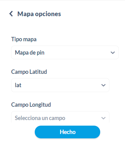
And there are no results. Only a map of the USA that these coordinates don't correspond to the latitudes and longitudes I'm inputting. The coordinates I'm trying to find are from Argentina.
Maybe the issue is that the api map from OpenStreet maps only captures latitudes and longitudes from USA and not the rest of the world.
Thanks
{
  "browser-info": {
    "language": "es-ES",
    "platform": "Win32",
    "userAgent": "Mozilla/5.0 (Windows NT 10.0; Win64; x64) AppleWebKit/537.36 (KHTML, like Gecko) Chrome/93.0.4577.63 Safari/537.36",
    "vendor": "Google Inc."
  },
  "system-info": {
    "file.encoding": "UTF-8",
    "java.runtime.name": "OpenJDK Runtime Environment",
    "java.runtime.version": "11.0.11+9",
    "java.vendor": "AdoptOpenJDK",
    "java.vendor.url": "https://adoptopenjdk.net/",
    "java.version": "11.0.11",
    "java.vm.name": "OpenJDK 64-Bit Server VM",
    "java.vm.version": "11.0.11+9",
    "os.name": "Linux",
    "os.version": "5.4.129-63.229.amzn2.x86_64",
    "user.language": "en",
    "user.timezone": "America/Argentina/Buenos_Aires"
  },
  "metabase-info": {
    "databases": [
      "postgres",
      "googleanalytics",
      "presto"
    ],
    "hosting-env": "unknown",
    "application-database": "postgres",
    "application-database-details": {
      "database": {
        "name": "PostgreSQL",
        "version": "10.17"
      },
      "jdbc-driver": {
        "name": "PostgreSQL JDBC Driver",
        "version": "42.2.18"
      }
    },
    "run-mode": "prod",
    "version": {
      "date": "2021-08-26",
      "tag": "v0.40.3.1",
      "branch": "release-x.40.x",
      "hash": "0550b86"
    },
    "settings": {
      "report-timezone": "America/Buenos_Aires"
    }
  }
}
 on the first post